TOPOGRAPHICAL MAP     Click
here to see a broader view of this map, a part of which
was copied from http://www.topozone.com/map.asp?z=17&n=3880754&e=453766
|
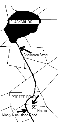
From Blacksburg, SC, travel on Charleston Street about three and a half miles south. Continue south on Ninety Nine Island Road (the right or west fork) for about one mile and turn left (east) onto Porter Road. An old Porter family farm house with running water and electiricity is about 200 feet south (right) of Porter road, on a small hill about one quarter mile from Ninety Nine Island Road. The Porter family reunion is usually held in the back yard under a huge oak tree.
Old Chester Road (the left or east fork) also intersects Porter Road about a mile south of the aforesaid fork. Ninety Nine Island Road ends at the Broad River dam.
Click here to download a labeled bitmap image of the roads on the topographical map below.
| TOPOGRAPHICAL MAP Click
here to see a broader view of this map, a part of which
was copied from http://www.topozone.com/map.asp?z=17&n=3880754&e=453766
|